Executive Summary
The purpose of the Horsefly River (Secwepemcúl’ecw) Watershed Connectivity Restoration Plan (WCRP) is to improve connectivity for anadromous salmon and the livelihoods that they support, including the continued sustenance, cultural, and ceremonial needs of the Northern Secwépemc people and build collaborative partnerships within the Horsefly River watershed to achieve this goal. This plan aims to improve understanding of habitat connectivity for Sockeye Salmon (Oncorhynchus nerka), Chinook Salmon (O. tschawytcha), and Coho Salmon (O. kisutch); herein referred to as Pacific salmon, in the Horsefly River watershed (Secwepemcúl’ecw) and inform efforts to close knowledge gaps and plan and prioritize restoration. Local data and knowledge are combined with connectivity modelling to estimate current connectivity status and identify structures that potentially block the most habitat. This informs the prioritization of field assessments to close the most significant knowledge gaps efficiently. Information from field assessments of barrier status and habitat condition are incorporated into the model, improving understanding of which barriers block the most habitat, and informing restoration prioritization. As knowledge gaps are closed and barriers are addressed, this plan will be revised to summarize progress and provide updated estimates of connectivity status and the status and relative importance of remaining structures.
In the Horsefly River watershed, 259.43 km of Pacific salmon spawning and rearing habitat are currently connected to the ocean and 23.53 km are disconnected from it. This means that 91.7% of the 282.96 km of total habitat is connected.
In the Horsefly River watershed, 33 structures potentially disconnect Pacific salmon spawning or rearing habitat. Of these, 16 are identified as barriers in need of rehabilitation (priority barriers), 7 are identified as barriers that do not warrant rehabilitation (non-actionable), and 11 require further field assessment.
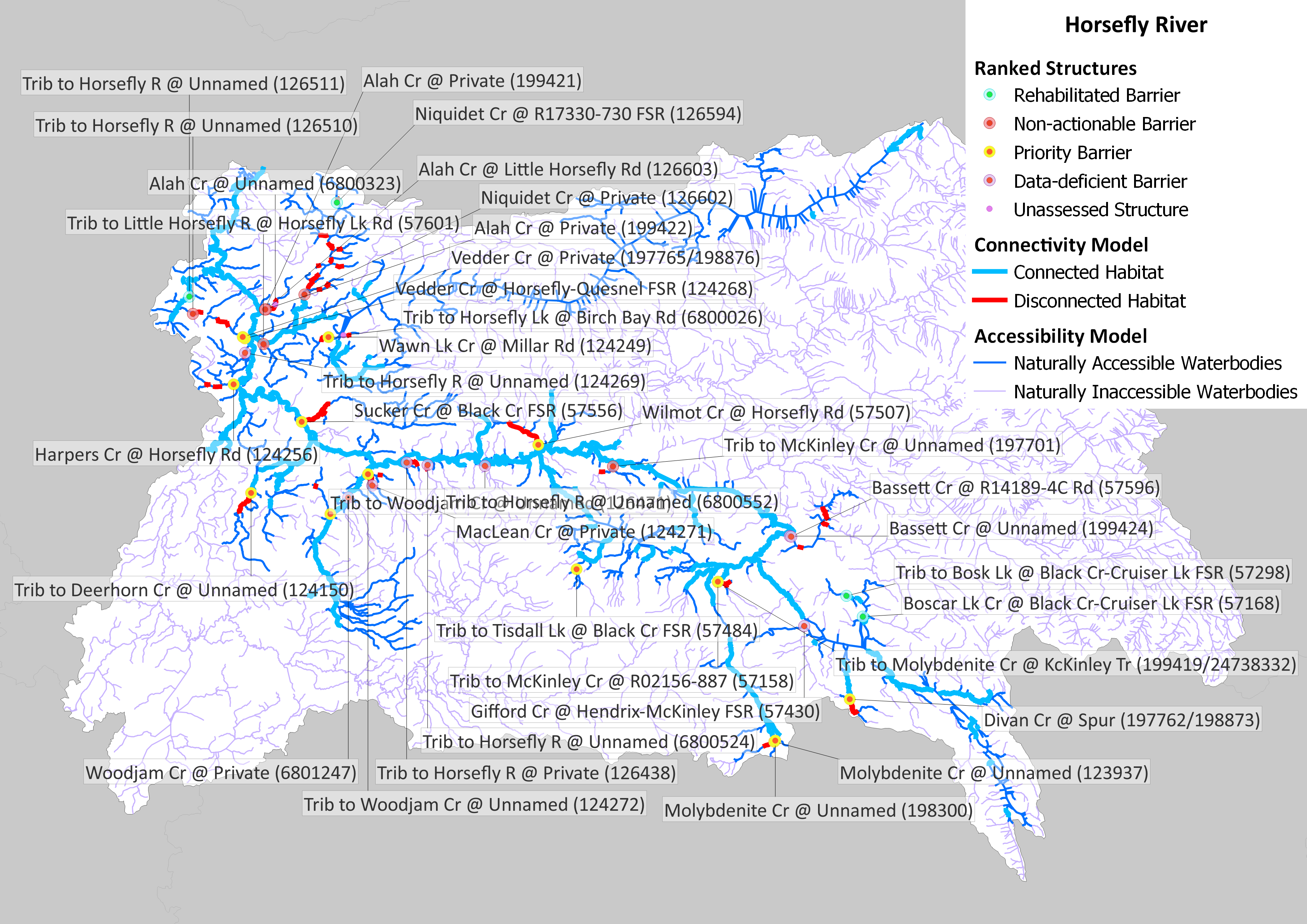

This WCRP was initiated in 2020. Since then, the passability of 100 structures has been assessed, and further habitat assessments were completed at 29 of these. Fish passage has been rehabilitated at 4 barriers: a culvert was removed and road deactivated on Boscar Lake Creek, and culverts on Niquidet Creek, an unnamed tributary to Bosk Lake, and an unnamed tributary to Horsefly River were replaced with clearspan bridges. This has resulted in improved or restored access to 4 km of spawning and rearing habitat. Lateral (side channel and off-channel) connectivity and thermal refugia were also assessed in a portion of the mainstem Horsefly River in 2022 by the Horsefly River Roundtable, Northern Shuswap Tribal Council and Williams Lake First Nation, and fish passage at 14 trail-stream crossings was also completed by the Williams Lake First Nation in 2022.